With just two months of training time left before the walk, now is the time for us to move into an active planning stage and to really bump up the training.
The training regime is really quite simple - walk... a lot, everywhere, with full weight, and then walk some more, and some more...
Also, the first part of the surveying of the more critical sections of the route has begun. Yesterday, myself an my wife Julie surveyed the newly reopened section of the route that bypasses the Lion Inn
This section is the crooked diagonal path you can see on the above map, with BS marked on it (boundary stone). It cuts several km off the route, but more importantly removes the temptation to go to the pub! We did go to the pub for lunch afterwards (jacket potato and prawns for me!), and suspect that this is where many people quit! It does have a bit of a boggy section at the start, but hopefully it wont be too bad on the day!
As part of the increased training, Bob is out running more, whilst I am also introducing a touch of Pilates, and the use of ankle weights when not actively training. These have the effect of simulating the wearing of very heavy hiking boots - increasing the strength and tone of the thigh muscles. Anywhere that I am actually walking properly, I will have the Clansman RT-320 radio on my back! Bob as I understand it carries his weight in the form of bottles of water. Next up is to start getting some long distance walking in, 10 or 15 miles or more at a time, and some ascent. Hopefully leading up to doing the Yorkshire Three Peaks as a training walk mid May.
Its also a time for technology upgrades! Whilst the two OS 1:25,000 maps and a Silva mk4-M compass are standard, my venerable old Garmin Etrex H GPSr was showing its age, and was found to be incapable of storing sufficient waypoints to guide us over the whole route. So I now have a shiny new Garmin Etrex 30, which is blisteringly fast and accurate, and can store thousands of waypoints. Bob also is obtaining one of these, so we should have tertiary redundancy on our navigation methods.
On a special note for our radio ham readers - The UK radio regulator Ofcom have agreed in principle to our request to operate as the UKs first ever pedestrian mobile Special Event Station! Sadly due to weight restrictions we will be operating only on 145MHz FM. We are just awaiting approval for a slight course correction (to include the above mentioned detour) and of our operating frequency, and the issuing of our special callsign. Hopefully we can announce this in the next week or so.
Also, look out for a post middle of next week when we will be promoting our walk, and the work of MAG, from the top of the Arqiva TV Tower in Emley Moor!
A blog about my Long Distance / Endurance walks and challenges, and charity challenges
Thursday, 23 April 2015
Saturday, 18 April 2015
Mines Awareness
In the last post, we talked about the walk we are planning, and how strenuous it is. This time, we want to consider why we are raising money by doing this on MAGs behalf
Probably most of you, when you hear the term 'landmine', think of big round containers, half buried in a road, to catch tanks. This is of course true, and these are, clearly, 'anti-tank mines'. They require a considerable force to detonate them, usually the weight of a tank or vehicle.
Few likely think of the smaller and much more dangerous 'anti-personnel mine'. These are small, hard to detect, versatile in trigger mechanisms, and designed to kill or wound unprotected infantry.
From a soldiers point of view, I can appreciate the tactical applications of these devices. They serve as a means to protect an area, deny an area to the enemy, or to direct the enemy into a pre-determined 'kill zone'. Certain anti-personnel mines are designed to be 'command' detonated, that is, they are triggered deliberately using a hand operated initiator.
This is the ubiquitous 'Claymore' mine. Although designed to be command detonated and used in area protection, it is also capable of being triggered by a trip wire.
When detonated, this device expels in a wide arc hundreds of steel balls, lethal to hundreds of meters.
Unfortunately, of the millions of landmines around the world, few are command detonated. Most are entirely 'dumb', they just wait for someone to step on them, or disturb a trip wire.
The problem is, that often minefields are not marked, or the records are lost during combat or after the conflict is over. And mines do not sign ceasefires and armistices. They do not recognize white flags, or UN banners. They do not care who wins, or who loses. And they dont care if the person who triggers them is a soldier, a farmer, a man, a woman, or a child.
Mines of this type are small. They typically contain very little metal, perhaps just in the trigger spring or the detonator, making them very hard to detect. They are typically coloured to match their surroundings. And they typically contain just enough explosive to destroy a limb.
Some, such as the one on the right, are 'blast' mines, that is they do their work through the force of the explosives alone, typically wounding only the person who triggers it.
This is an ELSIE. A Canadian designed blast mine. It is very small, designed to be buried up to the rim, leaving the tiniest part above surface. It will take your foot off! It is another of the blast mines.
The mine on the right, is a fragmentation mine. This design is triggered by a trip wire. when detonated, it showers steel fragments all around it. This means it can wound or kill not only the person who triggers it, but those around them
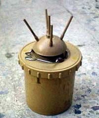
The last type of mine I want to mention is typified by the Valmara
Triggered by the slightest touch of its prongs, this mine does not detonate immediately. First, a projecting charge fires, which lifts the main mine charge into the air to about 1m - thats around groin height on an adult, chest or head height on a child - before the main charge detonates. These are known as bounding mines.
The photo left shows a MAG deminer working on defuzing a Valmara.
Its quite clear, that even on the largely clear terrain this one is in, its not easy to see.
There are millions of mines still in the ground around the world, most long after the conflict that put them there has ended. Now, the only people likely to trigger them are farmers and children.
But mines laid in the ground are not the only problem. Aerial bombing using cluster munitions, that is, large bombs that open during flight to disperse hundreds of small 'bomblets', have left many parts of the world littered with unexploded ordnance.
The country of Laos is a prime example. It is perhaps the most bombed country on the planet, despite not having been at war at the time! During the Vietnam war, parts of Laos adjacent to the Vietnamese border were part of the Ho Chi Minh trail - the supply route from the north for the North Vietnamese Army and the Viet Minh. In its attempts to shut this supply route down, the USAF dropped millions of tonnes of munitions, of which around 30% failed to detonate. The result is a landscape with around 80 MILLION unexploded sub-munitions!
Vietnam era cluster sub-munitions, or 'bombies'
Almost impossible to tell apart from other stones and rocks, these remain lethal over forty years later.


The big problem with these, is that they are so hard to see, and when they are seen, often by children, they look interesting, even toy like. More modern sub-munitions may still retain their highly visible yellow 'High Explosive' markings. This is fine for identifying them to soldiers and armourers, who know what the colour means, but it also makes them appealing to children, who can think they are toys.
To make things worse, the same bright colouring has been used to identify air dropped humanitarian aid packages!
So these are the sorts of things MAG is trying to remove. Each one small, each one lethal.
I have deliberately NOT set out to shock in this post. Only to show the kind of things that are out there. In a future post I will discuss mine and UXO trauma and injuries. That post will shock, whether intended to or not.
Another near future post will concentrate on the work of MAG around the world, and how MAG are slowly finding and destroying these infernal machines, but also how their mines awareness eduction programmes are teaching children in some of the worlds poorest countries how to identify mines and UXO, and what to do if they find them.
If you have read this post and feel as we do that more effort must be made to rid the world of the detritus of war, then please take the time to click our link above and support us with whatever you can spare!

Probably most of you, when you hear the term 'landmine', think of big round containers, half buried in a road, to catch tanks. This is of course true, and these are, clearly, 'anti-tank mines'. They require a considerable force to detonate them, usually the weight of a tank or vehicle.
Few likely think of the smaller and much more dangerous 'anti-personnel mine'. These are small, hard to detect, versatile in trigger mechanisms, and designed to kill or wound unprotected infantry.
From a soldiers point of view, I can appreciate the tactical applications of these devices. They serve as a means to protect an area, deny an area to the enemy, or to direct the enemy into a pre-determined 'kill zone'. Certain anti-personnel mines are designed to be 'command' detonated, that is, they are triggered deliberately using a hand operated initiator.
This is the ubiquitous 'Claymore' mine. Although designed to be command detonated and used in area protection, it is also capable of being triggered by a trip wire.
When detonated, this device expels in a wide arc hundreds of steel balls, lethal to hundreds of meters.
Unfortunately, of the millions of landmines around the world, few are command detonated. Most are entirely 'dumb', they just wait for someone to step on them, or disturb a trip wire.
The problem is, that often minefields are not marked, or the records are lost during combat or after the conflict is over. And mines do not sign ceasefires and armistices. They do not recognize white flags, or UN banners. They do not care who wins, or who loses. And they dont care if the person who triggers them is a soldier, a farmer, a man, a woman, or a child.
Mines of this type are small. They typically contain very little metal, perhaps just in the trigger spring or the detonator, making them very hard to detect. They are typically coloured to match their surroundings. And they typically contain just enough explosive to destroy a limb.
Some, such as the one on the right, are 'blast' mines, that is they do their work through the force of the explosives alone, typically wounding only the person who triggers it.
This is an ELSIE. A Canadian designed blast mine. It is very small, designed to be buried up to the rim, leaving the tiniest part above surface. It will take your foot off! It is another of the blast mines.The mine on the right, is a fragmentation mine. This design is triggered by a trip wire. when detonated, it showers steel fragments all around it. This means it can wound or kill not only the person who triggers it, but those around them
The last type of mine I want to mention is typified by the Valmara
Triggered by the slightest touch of its prongs, this mine does not detonate immediately. First, a projecting charge fires, which lifts the main mine charge into the air to about 1m - thats around groin height on an adult, chest or head height on a child - before the main charge detonates. These are known as bounding mines.
The photo left shows a MAG deminer working on defuzing a Valmara.
Its quite clear, that even on the largely clear terrain this one is in, its not easy to see.
There are millions of mines still in the ground around the world, most long after the conflict that put them there has ended. Now, the only people likely to trigger them are farmers and children.
But mines laid in the ground are not the only problem. Aerial bombing using cluster munitions, that is, large bombs that open during flight to disperse hundreds of small 'bomblets', have left many parts of the world littered with unexploded ordnance.
The country of Laos is a prime example. It is perhaps the most bombed country on the planet, despite not having been at war at the time! During the Vietnam war, parts of Laos adjacent to the Vietnamese border were part of the Ho Chi Minh trail - the supply route from the north for the North Vietnamese Army and the Viet Minh. In its attempts to shut this supply route down, the USAF dropped millions of tonnes of munitions, of which around 30% failed to detonate. The result is a landscape with around 80 MILLION unexploded sub-munitions!
Vietnam era cluster sub-munitions, or 'bombies'
Almost impossible to tell apart from other stones and rocks, these remain lethal over forty years later.


The big problem with these, is that they are so hard to see, and when they are seen, often by children, they look interesting, even toy like. More modern sub-munitions may still retain their highly visible yellow 'High Explosive' markings. This is fine for identifying them to soldiers and armourers, who know what the colour means, but it also makes them appealing to children, who can think they are toys.
To make things worse, the same bright colouring has been used to identify air dropped humanitarian aid packages!
So these are the sorts of things MAG is trying to remove. Each one small, each one lethal.
I have deliberately NOT set out to shock in this post. Only to show the kind of things that are out there. In a future post I will discuss mine and UXO trauma and injuries. That post will shock, whether intended to or not.
Another near future post will concentrate on the work of MAG around the world, and how MAG are slowly finding and destroying these infernal machines, but also how their mines awareness eduction programmes are teaching children in some of the worlds poorest countries how to identify mines and UXO, and what to do if they find them.
If you have read this post and feel as we do that more effort must be made to rid the world of the detritus of war, then please take the time to click our link above and support us with whatever you can spare!
Friday, 17 April 2015
The Lyke Wake Walk Challenge
So, were going to be walking the Lyke Wake Walk - so what? Its just a 'walk' isn't it? Whys it so special? What makes it a 'challenge'?
I'll explain, but first, if you havent already - click here - Sponsor Us!
The name 'Lyke Wake' comes from old English, and in particular northern Yorkshire dialect. Many of you will be familiar with the modern use of the term 'wake' - a funeral bun fight! But the term is much older, coming from the fact that before modern medicine, many diseases could produce symptoms that mimicked death, deep coma etc, so a body would be laid out, and a 'wake' held - that is, the body would be watched day and night, for several days, to be absolutely sure they were dead.
The old Yorkshire dialect name for a corpse is the 'Lyke'. After completing the wake, the Lyke would need to be taken to the cemetery. In the bleak remote settlements of the Yorkshire Moors, the parish church could be a long way away. If the Lyke was that of a high status person, they would perhaps be taken to Rosedale or Whitby, to the abbeys.
Over the years, routes became established across the moors, wherever possibly keeping to the high ground or contours, over which the Dirgers, the old term for mourners, would carry the Lyke, to reach the church or abbey. This strenuous procession would cross the moors, leading the deceased to their place of interment.
The Lyke Wake Walk pays homage to these dirgers and their processions, by crossing the moors from Osmotherly in the West, to Ravenscar in the East, following the same routes and terrain as the old dirgers would have. What makes it so strenuous and a challenge is that the route crosses the entire moor! Some 65km (40 miles)
The challenge, is to complete the route in under 24h.
The two Ordnance Survey maps that cover the route are the 1:25,000 scale OL26 and OL27. The route starts at the left of one sheet, and ends at the right of the other!
Some of the route now follows disused railway tracks, and a section has recently been reopened that diverts away from the Lion Inn, at roughly halfway, and shaves a couple of km off.
Above is a Google Earth image with the route marked. The route crosses the two main summits of Drake Howe and Round Hill, passes to the north of the Bilsdale TV transmitter and Rosedale abbey, crosses the North York Moors Railway, skirts the PAVE-PAWS early warning radar station at RAF Flylingdales, and finally deposits its weary wanderers beside a rather nondescript communications tower a mile or two from the sea.
The route does cross several roads, and many walkers arrange for others to meet them on these crossing points to replenish food and water, have a rest, and sort their feet. These are known as 'supported' crossings.
We will be 'Unsupported'
That means we will have no one to meet, except possibly at the finish! Therefore we must carry with us all food, foot care, and especially water! We have calculated that we need 10 litres each minimum - thats 10kg plus of fluids to carry each, on top of other kit! 17-20kg starting weight would seem likely, and thats heavy! Of course, as we go, it will become lighter as we use up the water.
Unsupported also means that there is no way to quit! We cant just jack it in at one of the road crossings, as there is no one to get us back from them. For us, once we hit the trail, we are committed to getting through to Ravenscar.
This image shows the climb were up against. The worst of it is in the first 15 miles, roughly to the top of the second summit. We will be looking at completing as much of this as possible as a night march, getting it out of the way as early as possible.
If we complete this in under 24h, not only do we raise much needed funds for MAG, but we also become eligible to call ourselves Dirgers, and are members of the Lyke Wake club. I for one am looking forward to adding that black coffin badge to my walking hat!
I'll explain, but first, if you havent already - click here - Sponsor Us!


The name 'Lyke Wake' comes from old English, and in particular northern Yorkshire dialect. Many of you will be familiar with the modern use of the term 'wake' - a funeral bun fight! But the term is much older, coming from the fact that before modern medicine, many diseases could produce symptoms that mimicked death, deep coma etc, so a body would be laid out, and a 'wake' held - that is, the body would be watched day and night, for several days, to be absolutely sure they were dead.
The old Yorkshire dialect name for a corpse is the 'Lyke'. After completing the wake, the Lyke would need to be taken to the cemetery. In the bleak remote settlements of the Yorkshire Moors, the parish church could be a long way away. If the Lyke was that of a high status person, they would perhaps be taken to Rosedale or Whitby, to the abbeys.
Over the years, routes became established across the moors, wherever possibly keeping to the high ground or contours, over which the Dirgers, the old term for mourners, would carry the Lyke, to reach the church or abbey. This strenuous procession would cross the moors, leading the deceased to their place of interment.
The Lyke Wake Walk pays homage to these dirgers and their processions, by crossing the moors from Osmotherly in the West, to Ravenscar in the East, following the same routes and terrain as the old dirgers would have. What makes it so strenuous and a challenge is that the route crosses the entire moor! Some 65km (40 miles)
The challenge, is to complete the route in under 24h.
The two Ordnance Survey maps that cover the route are the 1:25,000 scale OL26 and OL27. The route starts at the left of one sheet, and ends at the right of the other!
Some of the route now follows disused railway tracks, and a section has recently been reopened that diverts away from the Lion Inn, at roughly halfway, and shaves a couple of km off.
Above is a Google Earth image with the route marked. The route crosses the two main summits of Drake Howe and Round Hill, passes to the north of the Bilsdale TV transmitter and Rosedale abbey, crosses the North York Moors Railway, skirts the PAVE-PAWS early warning radar station at RAF Flylingdales, and finally deposits its weary wanderers beside a rather nondescript communications tower a mile or two from the sea.
The route does cross several roads, and many walkers arrange for others to meet them on these crossing points to replenish food and water, have a rest, and sort their feet. These are known as 'supported' crossings.
We will be 'Unsupported'
That means we will have no one to meet, except possibly at the finish! Therefore we must carry with us all food, foot care, and especially water! We have calculated that we need 10 litres each minimum - thats 10kg plus of fluids to carry each, on top of other kit! 17-20kg starting weight would seem likely, and thats heavy! Of course, as we go, it will become lighter as we use up the water.
Unsupported also means that there is no way to quit! We cant just jack it in at one of the road crossings, as there is no one to get us back from them. For us, once we hit the trail, we are committed to getting through to Ravenscar.
This image shows the climb were up against. The worst of it is in the first 15 miles, roughly to the top of the second summit. We will be looking at completing as much of this as possible as a night march, getting it out of the way as early as possible.
If we complete this in under 24h, not only do we raise much needed funds for MAG, but we also become eligible to call ourselves Dirgers, and are members of the Lyke Wake club. I for one am looking forward to adding that black coffin badge to my walking hat!
Monday, 13 April 2015
Hello! And WHY?
Hello to all visiting this blog!
On the 28th June 2015, myself Martin G7MRV and Bob M1BBV, will be walking the route of the old Dirgers paths across the North Yorkshire Moors, between Osmotherly in the west and Ravenscar on the East coast.
We are doing this to raise money for MAG, the Mines Advisory Group, who work in some of the poorest and most war ravaged countries providing essential landmine and Unexploded Ordnance awareness education, landmine and minefield clearance, and UXO disposal. Their work returns land to the population for safe agricultural and educational use.
I have set up this blog to record not only the details of the walk, but to document our pre-planning, training, and fundraising. In the coming days, we will write here about our efforts, post pictures, and link to information about MAGs work.
You can support us in this endeavor by simply clicking and making a donation on our Just Giving page, here -
https://www.justgiving.com/MB-LykeWake2015/
Where you will see a running total of our donations. Myself and Bob do not ever see nor handle the money! Anything you donate goes direct to MAG! If you are UK based, please also sign up for Gift Aid, as that adds another 2.5% donation!
To find out more about the work of MAG, please follow this link
http://www.maginternational.org/
where there are stories, pictures and videos. There is also information on just what your donation can help them do!
As strenuous and long as the walk may be, we are planning to make it just a little more interesting, by also carrying a VHF radio and activating the two summits along the route as part of the amateur radio Summits On The Air (SOTA) program!
http://www.sota.org.uk/
Anyone who works our station as part of SOTA, or indeed any amateur radio station that works us during the walk, or any listeners who provide a reception report of hearing us, can claim a special QSL card to confirm the contact - On receipt of a donation of course!
For more details of the walk itself, look here - http://www.lykewake.org/route.php
So, who are we? -
The photos above were taken on a recent training walk on Kinder Scout. Im carrying an ex-military RT-320 HF manpack weighing in at 12kg, which Bob used to activate the summit for SOTA.
Myself and Bob grew up on the same street, getting into many scrapes and situations we shouldnt have! A common comment from between us after an expedition is "well, we didnt die again!". Bob spent so much time hanging around with me that he calls my mother his second mum!
Our target for this walk is £500, but we would love to go further!
My employer has agreed to match whatever we raise, up to our target. So if we hit the mark, Arqiva will add another £500 to the total! So lets make sure we get there!
Along with long distance training walks and SOTA activations, myself and Bob are putting in lots of extra walking and running training for this. A positive advantage of which is for me losing the belly ive acquired over the last 10years working in a control room!
Much more to follow, including photos from training walks, and details of the preparations for the radio operation
oh, and the link again! - https://www.justgiving.com/MB-LykeWake2015/
On the 28th June 2015, myself Martin G7MRV and Bob M1BBV, will be walking the route of the old Dirgers paths across the North Yorkshire Moors, between Osmotherly in the west and Ravenscar on the East coast.
We are doing this to raise money for MAG, the Mines Advisory Group, who work in some of the poorest and most war ravaged countries providing essential landmine and Unexploded Ordnance awareness education, landmine and minefield clearance, and UXO disposal. Their work returns land to the population for safe agricultural and educational use.
I have set up this blog to record not only the details of the walk, but to document our pre-planning, training, and fundraising. In the coming days, we will write here about our efforts, post pictures, and link to information about MAGs work.
You can support us in this endeavor by simply clicking and making a donation on our Just Giving page, here -
https://www.justgiving.com/MB-LykeWake2015/
Where you will see a running total of our donations. Myself and Bob do not ever see nor handle the money! Anything you donate goes direct to MAG! If you are UK based, please also sign up for Gift Aid, as that adds another 2.5% donation!
To find out more about the work of MAG, please follow this link
http://www.maginternational.org/
where there are stories, pictures and videos. There is also information on just what your donation can help them do!
As strenuous and long as the walk may be, we are planning to make it just a little more interesting, by also carrying a VHF radio and activating the two summits along the route as part of the amateur radio Summits On The Air (SOTA) program!
http://www.sota.org.uk/
Anyone who works our station as part of SOTA, or indeed any amateur radio station that works us during the walk, or any listeners who provide a reception report of hearing us, can claim a special QSL card to confirm the contact - On receipt of a donation of course!
For more details of the walk itself, look here - http://www.lykewake.org/route.php
So, who are we? -
Martin G7MRV. Ex- KOYY(LI) reservist, Senior Network Operator for Digital Television with Arqiva. Hillwalker, Radio Ham, Astronomer, general jack of all trades. SOTA activator.
Bob M1BBV. Ex-7RHA. Hostel manager for the YMCA. Fitness freak, Bouncer, Boxer,
new SOTA activator
The photos above were taken on a recent training walk on Kinder Scout. Im carrying an ex-military RT-320 HF manpack weighing in at 12kg, which Bob used to activate the summit for SOTA.
Myself and Bob grew up on the same street, getting into many scrapes and situations we shouldnt have! A common comment from between us after an expedition is "well, we didnt die again!". Bob spent so much time hanging around with me that he calls my mother his second mum!
Our target for this walk is £500, but we would love to go further!
My employer has agreed to match whatever we raise, up to our target. So if we hit the mark, Arqiva will add another £500 to the total! So lets make sure we get there!
Along with long distance training walks and SOTA activations, myself and Bob are putting in lots of extra walking and running training for this. A positive advantage of which is for me losing the belly ive acquired over the last 10years working in a control room!
Much more to follow, including photos from training walks, and details of the preparations for the radio operation
oh, and the link again! - https://www.justgiving.com/MB-LykeWake2015/
Subscribe to:
Posts (Atom)